
Source: FEMA, National Flood Insurance Program Guidebook, 2009
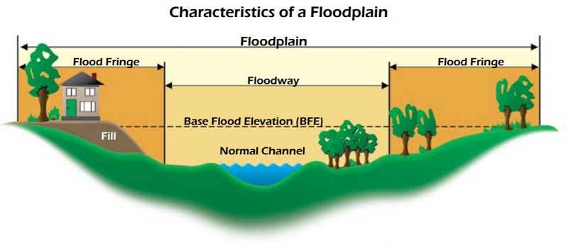
The Federal Emergency Management Administration (FEMA) defines a floodplain as any area of land prone to flooding from various sources. This encompasses coastal regions affected by storm surges, riverbanks or bayous susceptible to overflow, and low-lying areas that become inundated during heavy rainfall. Flooding can occur in diverse landscapes due to precipitation or storm surges.
A floodway is described as “the channel of a river or watercourse and the adjacent land areas that must be reserved to discharge the base flood without significantly increasing the water surface elevation beyond a specified height.” During a flood event, the floodway serves as an integral part of the watercourse and carries flowing water.
The 1 percent (100-year) floodplain refers to land submerged during a flood with a 1 percent chance of occurring or being surpassed annually. Similarly, the 0.2 percent (500-year) floodplain represents land inundated during a flood with a 0.2 percent annual occurrence probability.
Base Flood Elevation (BFE) denotes the elevation of surface water resulting from a flood with a 1% chance of equaling or surpassing that level in any given year.
Floodplain maps and information on flood insurance coverage and requirements, flood protection measures, flood safety, and property and building protection are available at the City of Kingsville website. Property owners can take actions in advance of a flood to provide protection for their property. Large maps of floodplain areas can be obtained upon request. The price is to be determined based on the request.
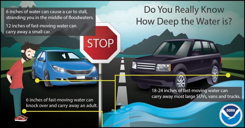
Safety Reminder: “Turn Around, Don’t Drown.” If you encounter water on the road, prioritize safety and opt for an alternate route.
Forms:
Residential Basement Floodproofing Certificate (PDF)
Non-Residential Floodproofing Certificate (PDF)
Helpful Resources:
Flood Damage Prevention Ordinance
Frequently Asked Questions (PDF)
Flood Risk Basics And Communities – A Customer Experience Toolkit Video
Flood Risk Communication Video Series
Getting Ready For Disaster – a Family’s Experience
Being Ready for Disasters Take Preparation. Know your risk, make a plan, build a kit
Find Your Home’s Flood Factor
Flood Mapping Resources
Map Layers of Flood Gauges
View and Obtain Flood Maps